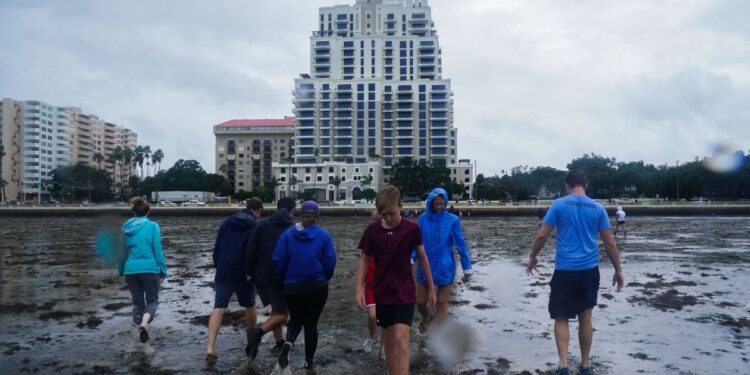
Tampa Bay area residents are sharing shocking pictures of empty coastline as tidewater recedes during Hurricane Ian.
The images show long areas of mudflats as the hurricane nears with winds just shy of catastrophic Category 5 strength along Florida’s Gulf Coast.
New pictures from friends in Tampa #FL as Hurricane #Ian has sucked the water out of Tampa Bay! @ScrippsNational @abcactionnews pic.twitter.com/Td1ni6oZ5M
— Ashley Glass (@ashleygTV) September 28, 2022
A video of the strange sight shows the unique phenomenon that also occurred when Hurricane Irma struck five years earlier when the departing water returned with a surge of two feet.
Strange sight. 😳 #HurricaneIan has sucked water out of the Tampa Bay. This is similar to what happened during Irma 5 years ago. pic.twitter.com/NWHiC68uGD
— John-Carlos Estrada (@Mr_JCE) September 28, 2022
A screenshot from a Tampa area webcam along I-275 also shows the extended area of mud alongside the roadway as the hurricane sucks water from the coastline before water returns in a surge toward the beach areas.
Another user video captured footage of water being pulled away from a nearby canal area near Tampa Bay.
Video from my dad in Apollo Beach with very low water level in their canal as water is getting pushed out of Tampa Bay! #FLwx @CBS12 @TND @natwxdesk pic.twitter.com/HdvryEJITG
— Jennifer Collins 🚲 (@JenCollinsWx) September 28, 2022
Florida officials and weather experts have warned against walking in the mudflats. Water can quickly return, leading to potential drowning.
Florida’s Division of Emergency Management was quick to warn against individuals seeking to walk in the receding areas.
“STOP: Do not walk out into receding water in Tampa Bay or Charlotte Harbor – the water WILL return through storm surge and poses a life-threatening risk,” the agency tweeted as pictures and videos began to emerge.
🚨 STOP: Do not walk out into receding water in Tampa Bay or Charlotte Harbor – the water WILL return through storm surge and poses a life-threatening risk.
— FL Division of Emergency Management (@FLSERT) September 28, 2022
Meteorologists tracking the water level changes have noted the water has dropped in the bay area by approximately 11 feet. By Thursday, Ian is expected to make landfall with a surge of about 2.5 feet estimated for the same area, with the potential to reach up to six feet.
-11 feet predicted. Crazy. Water being sucked out of Tampa Bay https://t.co/cJuUVASTGV
— Jeff Berardelli (@WeatherProf) September 28, 2022
More than 2.5 million Florida residents are under evacuation orders, though anyone who has not yet fled is now being told it’s too late to get away from the storm. As of Wednesday, Governor Ron DeSantis (R-FL) warned that it was no longer safe for those in some regions to flee.
“If you are in any of those counties it is no longer possible to safely evacuate. It’s time to hunker down and prepare for the storm,” DeSantis said. “Do what you need to do to stay safe. If you are where that storm is approaching, you’re already in hazardous conditions. It’s going to get a lot worse very quickly. So please hunker down.”
DeSantis has declared a state of emergency in all 67 Florida counties in preparation for Ian. President Joe Biden also approved an emergency declaration for Florida on Saturday ahead of the growing hurricane threat.
In addition, Georgia Gov. Brian Kemp (R) issued an emergency declaration regarding the potential impact on its state, placing 500 National Guard troops on standby alert. Neighboring South Carolina is also warning residents of possible damage from the storms.
Ian has already left widespread damage across Cuba, where tens of thousands of people lost power and storm surges of five to eight feet were reported along the coast.


